
After months of searching for a comprehensive solution to display and update their regulatory documents, the City of Grimes partnered with enCodePlus to build their vision. Several documents were made accessible and interactive online, including:
• Code of Ordinances
• Zoning Regulations
• Comprehensive Plan 2018 Update • Visual Design Guidelines
• Heritage PUD
A plan navigator was created to help users explore the Comprehensive Plan 2018 Update. Development Calculators were also built and calibrated based on the Zoning Regulation. The site was launched at the end of 2020 with the support of Grimes’ planning staff. In 2021, the City partnered with enCodePlus again, this time to conduct a full editorial review of their Code of Ordinances. The editorial review corrected and unified word usage, internal and external cross- references, formatting, numbered lists, and more. All this preparation laid the groundwork that would allow staff to rewrite their Zoning Regulations in Fall of 2022.
Online permitting system for application submission, payment, plan review, tracking and issuing permits and approvals. Includes mapping and reporting capabilities.
Automatically archives and provides historical versions of code sections.
Automated email notice of published document updates.
Customizable calculator for on-the-fly computing of bufferyard widths, screening types and plant types and quantities
Customizable calculator for on-the-fly computing of acres number of dwelling units per acre and per development.
Customizable calculator for on-the-fly computing of fee amounts for application filing and permitting.
Customizable calculator to quantify the maximum allowable building floor area in proportion to lot area;
Customizable calculator for on-the-fly computing of landscaping material types and quantities by location.
Customizable calculator for on-the-fly computing of sign types, areas, heights and locations by district.
Secure document storage and retrieval system. Search ordinances by number, date or keyword.
Comprehensive glossary with 40,000+ (and counting) planning and zoning terms. Regularly updated.
Review by an editing professional to ensure clarity, style and accuracy with a focus on the technical aspects (grammar, formatting, spelling, consistency, punctuation, etc.) of an ordinance or code.
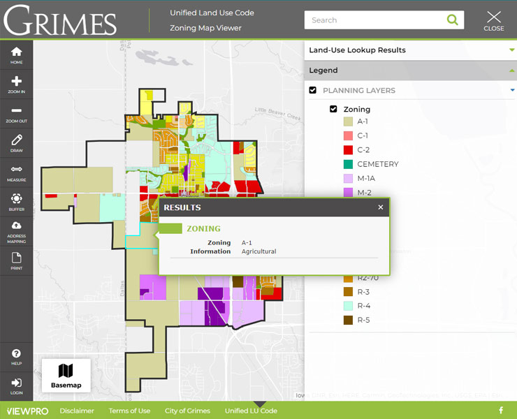
Esri-based GIS map application designed for planning and zoning queries, analyses, and display.
GIS map of districts where specific land uses are permitted by-right or by condition or special exception.