Take the tedium out of zoning research with purpose-built technology
The process of discovering what is possible for the development of a property is time-consuming and painstaking.
What is allowed? Where, how big, how tall? What are the parking and landscaping requirements? And what about the application requirements and multi-stage process to gain approvals?
The list of details needed is long and resources are disjointed.
THERE IS AN EASIER WAY
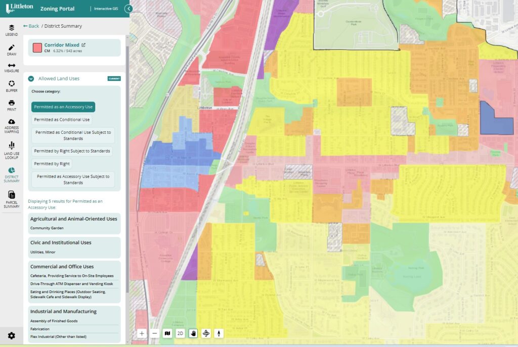
Now you can access comprehensive zoning information about any property and the district in which it is located with our District Summary Tool.
What does this mean to you?
Unparalleled, up-to-the-minute research requiring no manual updates from your staff.
Implement easy-to-use tools for comprehensive zoning research.
Two Simple ways to access the zoning district summary: GIS MAP OR SMARTSEARCH
Option 1: GIS Map
Click the property on a GIS map to instantaneously produce a wealth of zoning information for the entire district.
Fast, convenient research
Always up-to-date and accurate data
Simple, intuitive user experience
Easy-to-create, -print and -share reports
Option 2: SmartSearch
Simply type in an address or parcel identification number to reveal a downloadable report summarizing all the parcel- and zoning-related information about the property.
Query zoning within a district for a point, parcel, line or user-defined polygon
using gis mapping technology
The GIS-based map is hyperlinked directly to relevant sections of the zoning ordinance. The information is dynamic, so any update to the regulations automatically updates the map. You’ll find:
Title and abbreviation of the applicable zoning district(s)
Hyperlinks to all zoning regulations relevant to the property:
permitted, special, conditional, accessory, temporary and prohibited land uses
dimensional standards (front, side and rear setbacks; building height and coverage, etc.)
required parking, landscaping, signage and lighting
Downloadable version of the District Summary Report
Granular research of specifically-defined geographic areas, such as within a certain distance of a corridor or neighborhood or the exact boundaries of a small area planning study
Integrate with land use lookup for more context
Use with the Land Use Lookup Tool for an even more complete picture.
Now you can see a report reflecting all areas where a particular use is permitted and the regulations and standards that apply.
Search an address or parcel ID using SmartSearch, select a lot on a GIS map, or research land uses and districts to produce the zoning designation and description, as well as links directly to applicable sections of the code:
District purposes
Use tables
Supplemental use standards
Parking, sign and landscaping requirements
Applicable procedures
Understand more clearly the location and context of districts relative to a parcel, neighborhood and corporate limits.
Example: Land Use Summary
examples of District Summaries in action
Explore these examples to see how communities like yours are using district summaries to communicate in-depth district zoning data.
All your district zoning information, all in one place.
WE CAN BUILD AND LINK IT DYNAMICALLY TO YOUR ZONING ORDINANCE
Our intelligent GIS zoning map is the only one of its kind. Claim all the benefits.
Rely on its accuracy. Let the latest technology do the work for you.
Why enCodePlus?
Our team of planning experts and former government staff has been in your shoes and we understand your challenges. We developed a municipal government software platform with powerful capabilities and the flexibility to customize features according to the unique needs of individual communities. We built enCodePlus for you!