Dickinson is a nearly built-out enclave community nestled amongst several much larger and actively developing communities. It prides itself on being a quiet working-class bedroom community. What commercial development exists in principally along IH 45 with a few smaller businesses sprinkled along SH 3 and FM 517.
In recent years, the community has been ravaged by major storm events cause severe flooding across large portions of the community. This, in turn, led to vacancies and disinvestment in flood prone areas. In particular, at the crossroads of SH 3 and FM 517 is an area that has acted as the city center. It too, experienced a loss of tenants leading to urban blight.
New leadership placed a higher priority on advanced planning and proactive economic development. Seeing the area not as a problem but as an opportunity, Kendig Keast Collaborative (our parent company) was hired to prepare a redevelopment plan. To gain the support of city leaders, business and land owners in the project area and nearby residents, ArcGIS Urban was used to build alternative scenarios to gauge reactions to different types and scales of development.
Outcomes:
• A two-dimensional conceptual site plan was developed through the course of stakeholder meetings and a design charette.
Visualizes proposed projects in context to understand real-world impacts.
Automatically archives and provides historical versions of code sections.
Automated email notice of published document updates.
Customizable calculator for on-the-fly computing of bufferyard widths, screening types and plant types and quantities
Customizable calculator to identify and quantify the credits and bonuses for use of sustainable landscape elements
Customizable calculator for on-the-fly computing of landscaping material types and quantities by location.
Customizable calculator for on-the-fly computing of total parking space quantities for cars, trucks and bicycles.
Customizable calculator for on-the-fly computing of sign types, areas, heights and locations by district.
Secure document storage and retrieval system. Search ordinances by number, date or keyword.
Collation of content related to a specified topic. May include icons placed in headers, tables, or other parts of the document for quick identification and reference.
Comprehensive glossary with 40,000+ (and counting) planning and zoning terms. Regularly updated.
Virtual reality modeling using fly-through technology to simulate real-world conditions in three-dimensional context.
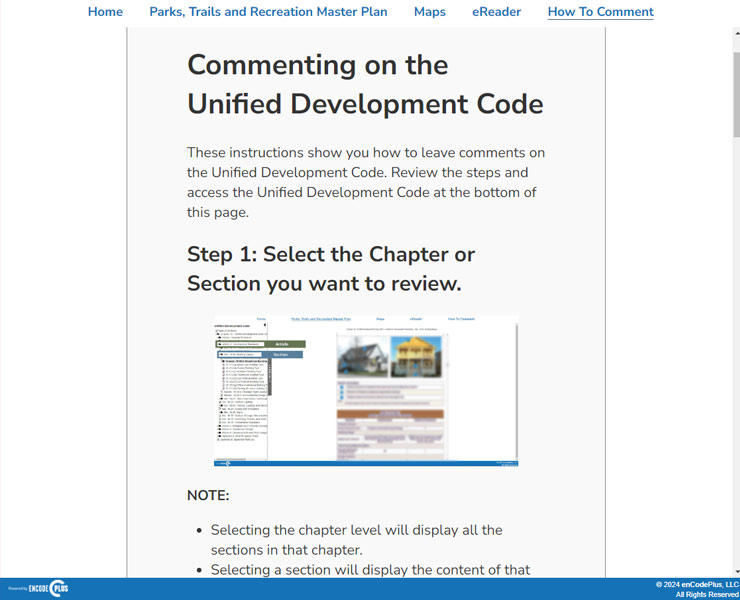
Optimized mobile and desktop document reading with navigation, printing, linking.
Esri-based GIS map application designed for planning and zoning queries, analyses, and display.
GIS map of districts where specific land uses are permitted by-right or by condition or special exception.
Use of ArcGIS Urban to build, visually depict and evaluate alternative building forms, land uses and performance metrics.
Organizes plans, ordinances and other document types into understandable sections and categories. Also referred to as Plan Navigator and Zoning Navigator.
Advanced user training to build technical competence on use of the platform.
Professional services to audit, amend, update or rewrite zoning and land development regulations.